Google has a new (free) service up and running in beta form: Google Maps. Bookmark it now, and just delete your bookmarks to MapQuest or Yahoo! Maps — Google Maps makes them just look silly.
First, the basic street maps on Google Maps are just plain better: easier to read, in my quick checks more up-to-date, and with a simple and very intuitive navigation scheme. There's something very clever going on under the covers that gives Google Maps a very superior user experience while (especially) panning around trying to find something.
But best of all...when you find the place you're looking for, you can just click on the "satellite" link on the upper right part of the screen, and poof! You've got a satellite photo of the same place, in quite high resolution. When I did this for my home, I could see not only my rooftop, but the surrounding trees, large shrubs, water tanks, and even my car! Very, very impressive.
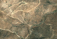
Just to give you a sample, at right is a section of a four-wheeling road we know well, called "Oriflamme Canyon" (click to get a full-sized view). The lower elevations are lower in the photograph, and you can see the tree-filled wash at the bottom (this is perhaps 25 feet across). Above it in the photograph you can see the four-wheel drive road, with a pair of switchbacks as it climbs the canyon wall. That road is just barely one car-width wide. You can also see side-washes descending from the road-cut into the main Oriflamme Canyon bottom. As I panned around this area (you can navigate wit the photos up just as easily!), I could pick out springs, streams, and areas where underground water made lush vegetation. This is high enough resolution to make an excellent hiking/four-wheeling planner. Amazing!
And it's all free. Google will make money, I presume, by targeted ads. For example, on the street map in my area I could see some restaurants and shopping areas marked. I suspect those markings will come in several graduations, and they will not be free to the vendor.

No comments:
Post a Comment